

Read the water like the fleet does.
The CATALYSST SoCal map packs live boats, satellite water data, and real catch intel onto one screen. Here's every symbol, what it means, and how the pros use it — so you know exactly what you're getting.
The symbols, decoded
Everything you'll see on the live map and what it's telling you.

See it in action
Actual screenshots from the live map — this is real data, not a mockup.
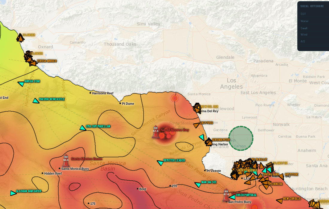
SST with temperature contours, the live fleet, and heatmap circles where boats stopped and worked. When several boats sit slow in one spot, that's not a coincidence — that's the bite.
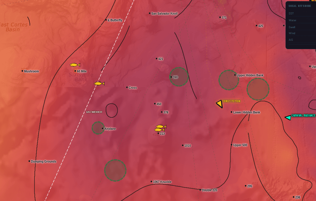
Fish icons mark confirmed catches — color shows freshness. Here: catches sitting right on a temp edge near the offshore banks, with fleet stop-circles around them. Tap any pin for species and timing.
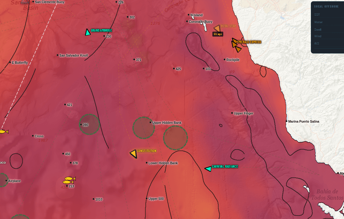
The rings are zones the fish-spotting planes circled — when a spotter orbits a patch of ocean, something made them look. Swordfish spotters draw in purple and every other spotter draws in green, and each layer toggles on its own, so you can tell a broadbill orbit from a tuna orbit at a glance. Overlay them on SST and the fleet and you've got a head start nobody at the dock has.
What your subscription actually does
1km sea-surface temperature (the same MUR data the pros use) plus 750m chlorophyll, with 1, 3, and 7-day composites, contour lines, and a cursor readout in °F. Temperature breaks and color edges are where bait stacks up — and where the tuna, yellowtail, and dorado hunt.
Every AIS-broadcasting boat in the Bight, live, with speed-colored trails. Hit play and watch the last three days unfold — where the fleet ran, where it stopped, and where it stayed. Nobody stays on dead water.
We cross the fleet's slow-speed clusters with verified catch reports to paint where the bite actually happened — not where someone said it did.
A full written report four times a day: NOAA conditions by zone, island-by-island coverage from the Coronados to the Channel Islands, offshore banks near and far, below the border, a live bait table for every receiver from San Diego to Santa Barbara, and a bottom line that tells it straight.
Route planner in nautical miles, live NOAA buoys, GPS position with distance readout, MPA and Navy zone overlays, and the US–Mexico border line.
Questions, answered
▸Why do temperature breaks matter so much?
Warm and cool water masses meet at a 'break' — bait gets concentrated along it, and the predators follow. A half-degree edge that holds for a few days is worth more than any rumor. The SST layer shows you exactly where those edges sit, updated daily at 1km resolution.
▸What does the chlorophyll layer tell me?
Chlorophyll marks plankton-rich green water versus clean blue ocean water. The clean-to-green transition is a feeding lane: offshore species like tuna and dorado patrol the blue side of the color break. Layer it with SST and you're fishing structure most people can't see.
▸How fresh is the data?
Boats update live, around the clock. Buoys refresh continuously through the day. Satellite SST and chlorophyll process several times a day as new passes come in, and the written report publishes four times daily — including a live bait table for the receivers.
▸Is it legal to watch the boats?
Completely. Commercial and sport vessels broadcast AIS publicly for safety — we just put it on a map that fishermen can actually use, with history and playback.
▸Does it work on my phone?
Yes — the map runs in any modern browser on phone, tablet, or desktop. Offshore beyond cell coverage you won't get live updates, so the move is to study the layers and set your route before you leave the harbor.
▸What's the difference between SoCal and All Access?
SoCal ($15.99/mo) is the specialized Southern California product — the densest data we make, including the daily written reports. All Access ($17.99/mo) adds every US and international region on top of it.
▸Can I try it first?
Every plan starts with a 7-day free trial, and you can cancel anytime in two clicks from your dashboard — no calls, no hoops.
Fish the next break, not the last rumor.
7-day free trial. $15.99/mo after. Cancel anytime.
Start my free trial