

SoCal Fishing Intelligence
A separate build of Catalysst for the Southern California Bight. Spotter-plane tracking and the verified-catch map ship only in this version — layered over the same temperature breaks, chlorophyll edges and live fleet AIS.
- Spotter aircraft
- Tracked live
- Sportboat fleet
- Live AIS
- Catches
- Verified & pinned
- Chart updates
- All day
Beat the Fleet
Aircraft found the water. Our members confirmed the fish — a full day before the fleet got there.
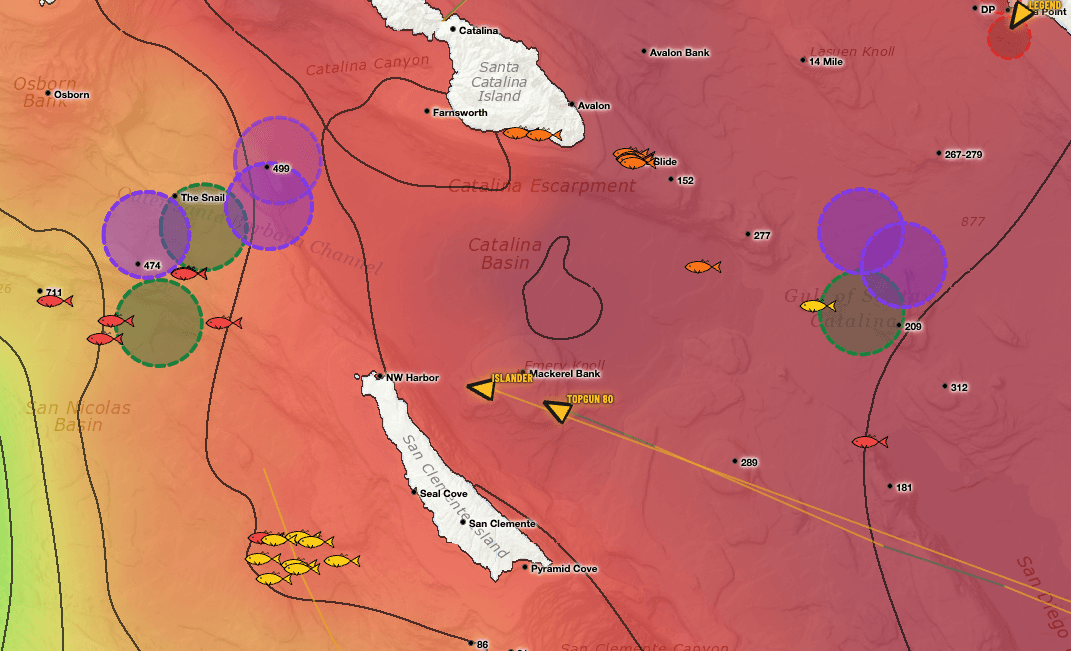
Spotter planes flagged the water first. Our members had fish confirmed on the deck while the sportboat fleet was still steaming toward the same spot — a full day behind.
How it went down
Three moves, one edgeAircraft interest lit up the west side
Spotter planes started stacking over Osborn Bank and the Snail. Circling aircraft are the earliest tell that bait — and fish — are piling into a zone, usually well before a single one hits a deck. On the chart, that interest reads as a cluster you can't miss.
Members read it and put fish on the deck
Catalysst members lined the aircraft interest up against the temperature break and went. Fish confirmed and pinned — while that water was still “unproven” to everyone working off yesterday's fish report.
The fleet was a full day behind
The Islander and the Topgun 80 were still traveling to that very spot — a full 24 hours behind fish our members had already confirmed. The private boats found the grade, worked it, and were headed in before the fleet arrived.
The edge that got them there first
Four layers, one screenSpotter-plane tracking
Every working aircraft, live and by track history — so you see interest building before it's news.
SST & chlorophyll
Daily temperature breaks and color edges rendered fine enough to fish the line, not the blob.
Live fleet AIS
Where every sportboat is, right now — and which way the fleet is leaning.
Verified catches
Real fish, pinned to real coordinates, aged by the hour so fresh intel stands out.
Get on the fish before the fleet
The same intel that beat the fleet in the channel — spotter planes, temp breaks, live AIS and verified catches — on one screen, updated all day.
Start your 7-day trialTwo layers you won’t find anywhere else.
Satellite water is table stakes. These two come from people — pilots in the air and anglers on the water — and they only ship in the SoCal app.
Somebody flew out and circled this water
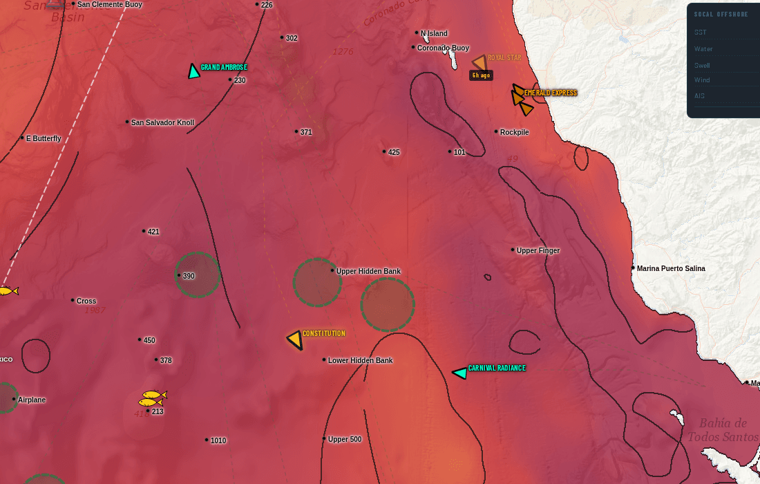
Fish-spotting planes work the Bight every day. When one stops and orbits a patch of ocean, the pilot is looking at something — bait, breezing fish, a paddy. We track that flight activity and draw the zones they circled straight onto your chart.
On the live chart, swordfish spotters draw in purple and every other spotter draws in green, each on its own toggle — so you can tell a broadbill orbit from a tuna orbit at a glance.
Real catches, pinned where they actually happened
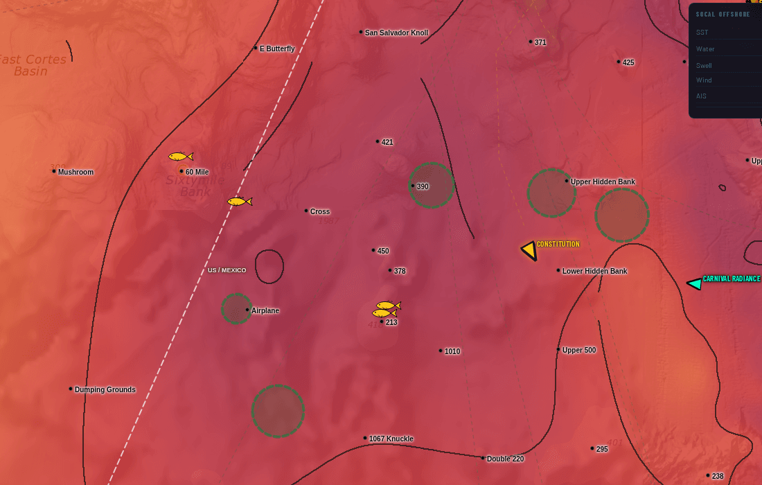
Every fish icon is a verified catch plotted at its real position — not a rumour, not a screenshot of somebody's dock talk. Colour shows how fresh it is, and tapping a pin gives you species and timing.
Lay it over the temperature break and the fleet's stop circles and the pattern shows itself: the catches stack on the edges, and you can see the bite move day to day.
Spotter-plane AOIs and the confirmed-catch map are part of the Southern California subscription. They are not included in the US or International versions. See the full SoCal guide.