Chlorophyll
Chlorophyll fishing maps (CHL)
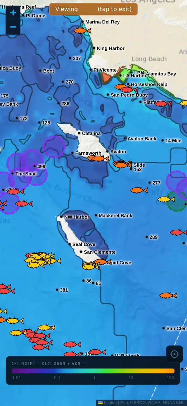
If sea surface temperature tells you where the predators hunt, chlorophyll tells you where the bait lives. Chlorophyll-a is the satellite's read of plankton density — the base of the food chain. Catalysst maps daily satellite chlorophyll so you can find the color edges where bait concentrates, and pair them with temperature breaks for the highest-percentage water.
What does chlorophyll tell you about fishing?
Chlorophyll-a measures plankton density in the water. More plankton means more bait, which means more predators. It's the food side of the equation that temperature alone can't show you.
Blue water is clean and low-productivity. Green water is rich with life. The edge between the two — the green-to-blue color line — is where bait piles up and the food chain stacks. It works like an SST break, but for productivity instead of temperature.
How to read a chlorophyll edge
You're hunting the color line, not the green or the blue itself. Fish don't sit in the dirtiest water or the cleanest water — they work the seam between them, where bait gets pushed up against the clean-water edge and gamefish ambush it.
The single highest-percentage spot offshore is where a chlorophyll edge lines up with an SST break. When the bait line and the temperature seam stack on top of each other, you've found water that has both the food and the conditions — that's where you start your day.
How Catalysst maps chlorophyll
Catalysst renders satellite chlorophyll (VIIRS and OLCI, depending on the region) on a log color scale from roughly 0.01 to 100 mg/m³, clipped to the coastline, with contour lines tracing the productivity edges. Like SST, it comes in 1-day, 3-day, and 7-day windows so you can find live edges and confirm they're holding.
Toggle chlorophyll on top of SST and the picture comes together fast: the temperature break shows the seam, the chlorophyll edge shows the bait, and where they overlap is the call.
Frequently asked
What is chlorophyll on a fishing map?
It's a satellite measurement of plankton density — the base of the ocean food chain. Green = rich, productive water with bait; blue = clean, low-productivity water. The edge between them is where bait, and therefore gamefish, concentrate.
Do you fish the green water or the blue water?
Neither — you fish the edge between them. Bait gets pushed against the clean-water line, and predators hunt that seam. The best spot is where a chlorophyll edge lines up with a sea surface temperature break.
How do you combine chlorophyll with sea surface temperature?
Overlay them. The SST break tells you where the temperature seam is; the chlorophyll edge tells you where the bait is. Where the two lines stack on top of each other is the highest-percentage water in the area.
See it in the app
7-day free trial. Plan your next trip from the dock.